
 Printer Friendly
 Email to a Friend
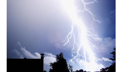
(MSC News)--The National Weather Service has issued a Severe Thunderstorm Watch for much of the local area, in effect until 10:00 Thursday night.
Local Kansas counties included are Atchison, Doniphan, Jefferson, and Leavenworth. Brown and Jackson Counties had originally been placed under the watch, but have since been removed by the National Weather Service.
Local Missouri counties included are Platte, Buchanan and Holt.
Possible primary threats include isolated areas of very large hail up to 2 inches in diameter, and isolated damaging wind gusts up to 70 mph.
The severe thunderstorm watch area is approximately along and 60 statute miles east and west of a line from 25 miles west northwest of Lamoni, Iowa to 45 miles south of Chanute, Kansas.
Remember: a severe thunderstorm watch means conditions are favorable for severe thunderstorms in and close to the watch area. Persons in these areas should be on the lookout for threatening weather conditions and listen for later statements and possible warnings. Severe thunderstorms can, and occasionally do, produce tornadoes.
© Many Signals Communications

|
MOST VIEWED STORIES
Atchison apt fire claim's toddler's life, injures others
Four arrested for illegal activity on Kickapoo Reservation
Effingham woman killed Friday in Atchison wreck
One injured in Nemaha Co wreck
Wetmore man arrested on child sex-related charge
Walnut Township Treasurer removed; votes unofficial until canvass
Rural Horton man arrested on multiple drug charges
Atchison man involved in fatal NW MO crash
Meteorologist Spencer: Geometric Watch means electronic disruptions
Street lights to be discussed at Monday city meeting
TX man to stand trial on charges in fatal Jackson Co crash
USD 430 Board accepts resignations, approves new hires
Local judge files for re-election
Atchison in running for national fireworks honors
Bridge work begins Wed in Doniphan Co
BC's Pate remembered by students, college family
Latest Brown, Doniphan Co filings
Planned outage for Brown-Atchison Electric Tuesday
LATEST STORIES
Atchison man involved in fatal NW MO crash
Effingham woman killed Friday in Atchison wreck
Street lights to be discussed at Monday city meeting
Truck fire at CGB facility in Falls City
Bridge work scheduled for Atchison County MO
Meteorologist Spencer: Geometric Watch means electronic disruptions
Rural Horton man arrested on multiple drug charges
Recycling program discussed at Doniphan Co meeting


Hiawatha, Ks 66434