
 Printer Friendly
 Email to a Friend
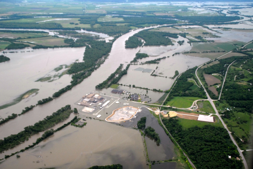
(KLZA)-- The forecast for heavy rain over parts of eastern Nebraska and western Iowa has led to the National Weather Service issuing flash flood watches in those areas.
A slow moving cold front is expected to trigger thunderstorms with rainfall amounts of up to five inches expected Monday evening through Wednesday morning. Up to two inches is possible in other parts of the states.
These storms are following heavy rain that occurred over the weekend in much of the same area.
The flood warnings continue along with Missouri River and the flood levels could be increasing another 2 – 5 feet at some gauges along the river.
At Rulo Monday morning the river reading was 22.73 feet with the crest predicted for Saturday afternoon at 24.8 feet. Flood stage is 17 feet at Rulo.
At Brownville Monday the river level was 39.94 feet which is nearly 6 feet above the 34 foot flood stage. The crest is predicted for Saturday afternoon at 44.8 feet which would be the second highest level on record. The record level was on March 16 of this year at 45.73 feet.
At Nebraska City the river level was 21.73 feet Monday morning. Flood stage is 18 feet and the crest is predicted for Friday morning at 24.1 feet.
Downstream at St. Joseph the river level was 23.84 feet Monday. 6.84 feet above flood stage with a crest of 26.4 feet predicted for Sunday morning.
At Atchison, Kansas, the Missouri River level Monday was 25.16 feet with a crest predicted at 28.9 feet Sunday evening. Flood stage at Atchison is 22 feet.
In addition, the National Weather Service has issued a flood warning for the Tarkio River at Fairfax. The Tarkio River is predicted to reach 24.7 feet Wednesday afternoon which is 7.7 feet above flood stage.
© Many Singals Communications
MOST VIEWED STORIES
Doniphan Co search warrant leads to 3 arrests
Horton truck driver seriously injured in Monday wreck
Sex crimes charges hold Atchison teen
Fleeing, drugs, hold Atchison man
Attempted bike escape earns prison stay
Atchison's USD 409 names new Superintendent
Falls City Officials respond to criticism
ATCH CO SO seeks tips regarding stolen motorcycle
Former 1st District Legislative candidate wins defamation case
Third day Superintendent candidate named by USD 409
USD 415 to begin alternative education program
Expansion of Atchison skatepark planned
NioCorp to begin 12-week drilling program
Olathe woman arrested in Jackson Co on drug charges
Hiawatha City Commission approves fireworks on trial basis
Longtime Sabetha Fire Chief to retire
Two new members appointed to Brown Co Planning Commission
USD 409's Honeywell named as superintendent finalist
LATEST STORIES
Spring cleaning time in the city of Horton
Summer EBT cards being distributed in Nebraska
Early morning power outage planned for Falls City
MO Congressman Graves critical of USPS
Grant apps for Falls City Amphitheater project denied
Jackson Heights names new MS/HS Principal
Seatbelt surveys coming to local counties
Commission approves bid for chip sealing county roadways
RELATED STORIES
Chance of Missouri River flooding increasing
High water releases to continue
Storm damage could mean tax breaks for Neb residents
Craig MO. residents ordered to evacuate
Moderate flooding forecast for Missouri River
Rainfall causing Missouri River to rise again


Hiawatha, Ks 66434