Left: Hail that fell Tuesday morning in Lancaster. Middle: Hail that fell in Centralia (Photo credit: Carol Deters) Right: Hail that fell in Farmington (Photo Credit: Bratten Forbes)
(KAIR)--Severe weather, round one, roared across the local area Tuesday morning, bringing with it strong, damaging winds, hail, and torrential rain.
Atchison County Emergency Preparedness Director Wes Lanter tells MSC News there have been reports of downed trees in both the City of Atchison and in rural areas of the county.
Powerlines were also downed, with Westar Energy crews going to work to make the needed repairs. As of 10:00 Tuesday morning, only a handful of outages remained in the local area.
A facility belonging to MGP Ingredients, in Atchison, sustained storm-related damage. Spokesman Steve Pickman tells MSC News a section of the roof at the company's protein and starch warehouse, located at 13th and Commercial Streets, incurred damage, believed to have been caused by the strong, morning wind. The damage assessment is ongoing.
Damage reports in Doniphan County have so far been minor, with Emergency Preparedness Coordinator Julie Meng telling MSC News one power line was downed in the old city of Doniphan, located in the southern part of the county.
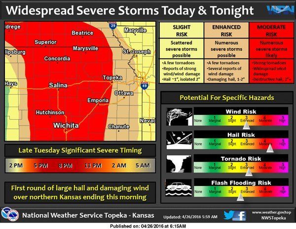
From the National Weather service: Round 1 of severe weather is in the books. Often when we have wide spread thunderstorms in the morning it really messes up the forecast for later in the day. Because of this morning's storms, there is more uncertainty than normal for our potential next round of severe weather. We are still getting indications that severe storms forming to our west this afternoon will eventually track back into our area this evening into the overnight hours. The most likely threat from these storms will be flooding, large hail, and damaging winds. The tornado threat diminishes rapidly from west to east. Due to the uncertainty, continue to watch the weather forecasts for future updates.
Kansas Emergency Management officials are using this latest round of severe weather to remind residents to be ready for any emergency situation. Below is a press release issued by the Kansas Division of Emergency Management:
Kansans are urged to check their emergency supplies and review their home emergency plan with every member of the family. A home emergency kit should include everything needed for each family member to survive for a minimum of three days without power. Kits should include one gallon of water per person per day; nonperishable, high energy foods; a battery powered NOAA weather radio; flashlights; extra batteries; a safe, alternate heat source; blankets; medications and other essentials. Pet owners are also reminded include their pets in their emergency preparations.
Discuss your home emergency plan in advance, including shelter locations at home or away from home. Designate a meeting location after the danger has passed so everyone can be accounted for.
If an emergency alert is issued for your area via emergency sirens, TV or radio alert or weather radio, take shelter immediately. The safest place in the home is the interior part of a basement. Avoid taking shelter where there are heavy objects, such as pianos or refrigerators, on the area of floor that is directly above you. They could fall though the floor if the tornado strikes your house.
If there is no basement, go to the lowest floor in a small center room such as a bathroom or closet, under a stairwell, or in an interior hallway with no windows. Crouch as low as possible to the floor, facing down; and cover your head; a motorcycle or bicycle helmet is good protection. For added protection, get under something sturdy such as a heavy table or workbench. A bath tub may offer partial protection. Because of the danger of broken glass and other sharp debris, be sure to wear shoes or have extra shoes as part of your emergency kit.
If you live in a mobile home, do not stay there. Leave immediately and go to the designated shelter or a nearby building.
For more informaion, go here, here and here.
© Many Signals Communications
MOST VIEWED STORIES
Holton man killed in Jackson Co crash
Morrill pair arrested on drug, child endangerment charges
Falls City man sentenced to Federal Prison
Ground Broken for new Sac and Fox Trad'n Post
Local residents avoid injury in chain reaction crash
Jackson Co traffic stop leads to arrest
90 mph+ downburst winds blamed for Thursday damage
One held for past Atchison shooting
Horton City Clerk's resignation accepted Monday
Inmate dies at Lansing Correctional Facility
Wamego man sentenced in second fentanyl-related death
Early Thursday storms leave damage, outages, locally
Stolen trailer, 4-wheeler, recovered in Atchison
Mayetta pair arrested on meth, child endangerment charges
Mound City Mayor Duane Nauman remembered
Juveniles face charges following Atchison break-in
Brown Co Planning Commission established
LATEST STORIES
Search warrrant served in Holton in cold case investigation
Senator Slama on tax relief efforts
SE Nebraska March unemployment report
Falls City Career Academy to open during 24-25 school year
Denim Day declared for Nebraska state colleges
McLouth man injured in Monday wreck
Horton City Clerk's resignation accepted Monday
Atchison Co's Oswald named honorary bailiff for KS Court
Juveniles face charges following Atchison break-in
Richardson County accepted into managed call handling program


 Printer Friendly
 Email to a Friend


